Not only is Canada hosting this year's G7 Leader's Summit, but it will also be happening nearby.
The G7 meeting will be held in Kananaskis Country from June 15 to 17 and will be causing extra security and closures in the area.
Because the G7 summit is considered to be a major international event, the RCMP has the mandate for the overall safety and security of all the world leaders who are in attendance.
The RCMP will lead the Integrated Safety and Security Group (ISSG), which includes the Calgary Police Service, the Alberta Seriff's Branch, Alberta Conservation Officers, and the Canadian Armed Forces, and will ensure there is a coordinated and unified approach to security at the G7 Summit.
The RCMP and the ISSG already have an established relationship and experience in the planning and delivery of security measures for major events.
Through the RCMP and ISSG partnership, they will be taking care of motorcade support, securing hotels and the sites where dignitaries will stay, deploying specialized teams, the transportation and processing of individuals who are charges with cries, and the wildlife management teams will reduce harmful human-wildlife interactions.
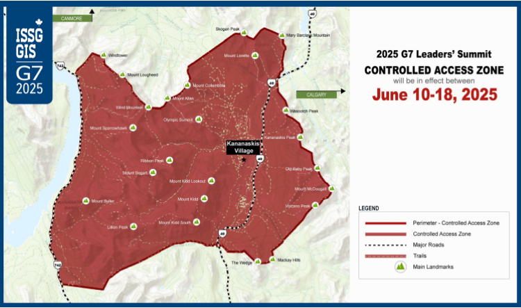
As part of the security measures for the summit, there will be a controlled access zone (CAZ).
The CAZ will be in effect between June 10 and June 18 in K-Country, but the security team will be doing their best to minimize the disruptions it will cause to those who are heading out to the area to explore and enjoy K-Country's beauty, all while providing security and safety to all those who are involved in the Leader's Summit.
Access to the control zone will be restricted to authorized personnel, residents, and businesses in the area, and accreditation is mandatory for everyone who wishes to access the CAZ.
Some hiking trails will be impacted by the Leader's Summit, but the RCMP is still working to identify which trails will be affected, and they will let the public know when they have it all figured out.
Where will the CAZ affect in K-Country?

No unauthorized vehicles will be allowed to travel past the Mount Lorette Ponds, south along Highway 40, which marks the Northern boundary, while there will be no unauthorized vehicles permitted to go past the Galatea Creek parking lot heading north along Highway 40, marking the Southern boundary.
There will be a significant security presence along the eastern slope of Highway 742, which marks the Western boundary.
While people will still be able to use Highway 742, all of the hiking trails along the eastern slope will be closed, but the trails west of Highway 741 will be open.
The Eastern boundary will extend along the eastern mountain ridgeline of the Kananaskis Valley.
To learn more, click here.
