Spring may be on the calendar, but winter isn’t backing down just yet. Environment Canada lifted the special weather statement for Airdrie early Thursday, but another blast of snow and freezing temperatures is on the way.
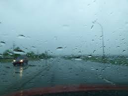
Airdrie residents should brace for a messy mix today, with a 30 per cent chance of rain showers this morning before periods of rain move in late morning and switch to snow by the afternoon. There’s also a risk of freezing rain early, and winds from the north will pick up to 20 km/h, gusting to 40 km/h. The high will hit 5 C, but wind chill will make it feel more like –8 C by late afternoon.
Periods of snow will taper off near midnight, leaving cloudy skies and a 60 per cent chance of flurries. Winds will ease as temperatures drop to –6 C, with the wind chill making it feel closer to –10 C.
Friday brings more snow after morning flurries, with temperatures hovering near –4 C and northeast winds reaching 20 km/h by the afternoon. Wind chill values will linger near –10 C. Snow will persist overnight as temperatures plunge to –9 C.
Saturday’s unsettled weather could bring more flurries, with a high of –5 C before skies clear somewhat overnight and temperatures drop to –15 C. By Sunday, sunny skies will offer a brief break, with a high of 5 C. But temperatures will fall again overnight, dipping to –11 C.
With freezing rain, snow, and fluctuating temperatures in the forecast, roads and sidewalks could turn treacherous, especially during the morning and evening commutes. Drivers should expect slippery conditions and reduced visibility, while pedestrians should watch for icy patches.
Although Airdrie is no longer under a weather advisory, areas west of the city aren’t as fortunate. Environment Canada has issued a snowfall warning for Banff and surrounding areas, including Lake Louise. As of 4:49 a.m. MDT Thursday, forecasters warned of heavy snowfall expected to drop between 10 and 20 cm by Friday morning, with some areas potentially receiving as much as 30 cm.
Snow will intensify through the day and remain heavy into the evening before easing to lighter periods on Friday. Accumulations may vary due to melting caused by warm temperatures and narrow snow bands that could lead to higher totals in localized areas. Drivers heading west should prepare for rapidly changing conditions and reduced visibility.
Sign up to get the latest local news headlines delivered directly to your inbox every afternoon.
Send your news tips, story ideas, pictures, and videos to news@discoverairdrie.com. You can also message and follow us on Twitter: @AIR1061FM.
DiscoverAirdrie encourages you to get your news directly from your trusted source by bookmarking this page and downloading the DiscoverAirdrie app.