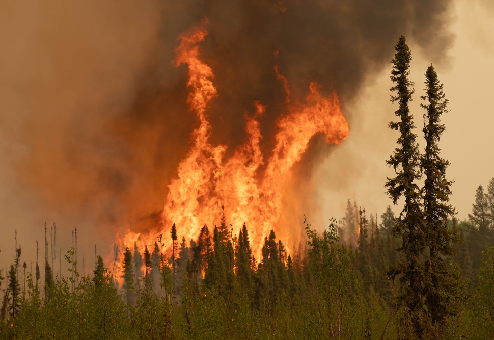
Saskatchewan is grappling with an unprecedented wildfire crisis. As of the June 3 situation update from the Saskatchewan Public Safety Agency (SPSA), there are 23 active wildfires across the province — nine not contained, four contained, eight under ongoing assessment, and two where the only thing emergency crews can focus on currently is protecting values such as communities and infrastructure.
Since January 1, 2025, the province has recorded 229 wildfires, well above the five-year average of 132.
"We have some challenging days ahead of us," Premier Scott Moe said during a June 3 SPSA press conference. "We are not through this, and the weather doesn't appear to be changing in the near future. Today, we're probably approaching in the neighborhood of 15,000 people that have been evacuated across the province, and are being supported in communities throughout Saskatchewan. More families are leaving their home as we speak, and so, thank you to all of the volunteers that have been involved in that evacuation.
"Thank you to all of the SPSA folks that are supporting that evacuation, the highway workers, everyone. Thank you to the community leaders, the folks that are fighting these fires on the front lines in places like La Ronge, in places like Creighton. You know, many families are leaving their home, and they don't know if they're going to see it again. They don't know if they're going to have the opportunity to go back there. They aren't just buildings. These are places where they have raised their family or are currently raising their family."
Wildfire “values” refer to buildings, power infrastructure, highways, and recreational sites threatened or already impacted by fires. The largest single wildfire, the Lower Fishing Lake (SHOE) fire, has grown to over 471,000 hectares as of June 4 and remains not contained. It threatens communities including Caribou Creek, Piprell Lake, East Trout Lake, and Little Bear Lake, necessitating large-scale evacuations and structure protection efforts .
To date, approximately 9,000 evacuees have registered for provincial support, but actual numbers may approach 15,000 as reporting continues. Communities fully evacuated include Creighton, Denare Beach, Lac La Ronge communities, Jan Lake, Pelican Narrows, Weyakwin, Molanosa Lake, Ramsey Bay, Timber Bay, and several cottage areas. Creighton and Denare Beach alone account for some 400 evacuees.
Many evacuees have relocated to Regina, Saskatoon, Prince Albert, and Montreal Lake, where community and volunteer groups are offering lodging, supplies, and emotional support. Hotel occupancy is high, but Emergency Crisis Support units stand ready to open congregate shelters — coordinated with the Red Cross — in Regina and Saskatoon if needed.
"We're not done," Moe added. "Today is not going to be an easy day. And tomorrow doesn't appear to be an easy day. We still have everyone in those communities that is battling on the very front lines ... in ... communities throughout the province. ... We need a change in the weather, and until we get it, we are, in many cases, fighting for our very lives."
Key Wildfire Highlights as of June 3
-
Lower Fishing Lake (SHOE) Fire (25LF): Report date May 7. 471,418 ha (not contained); threatens cabins, highways, parks, and communities north of Love Lake. Structure protection crews are working near Candle Lake and Whelan Bay; Highway 916 hot spots are being extinguished.
-
Jaysmith Fire (25LA): Report date May 20. Northeast of Missinipe, 88,099 ha (protecting values); Crews will do back burns from east of Brabant on Highway 102 to the north northeast along highway to tie into existing burn. During the burn, the highway will be closed and will reopen once it is completed, depending on the weather. Bucket support with Heli 352 and ground crew as needed. Continue servicing VP on the highway, Waddy Lake by boat and Inland Lakes by Float plane XRI. Crews will finish off the patrol and mopping up the mudline near Brabant.
-
25LA-PISEW (West of La Ronge): Report date May 21. West of La Ronge, estimated at 141,905.0 ha (not contained); Crews will be placed in Hall Lake, Sucker River, Wadin Bay, Nut Point and Bigstone. VPs will be serviced in Bigstone. VFD and Type 1 crews at Wadin and Sucker. Crews at Hall Lake with Heavy equipment and VFD. All other resources are based around the community of La Ronge. Heavy equipment will be utilized right at Bigstone.
-
25DB – WOLF (West of Denare Beach): Report date May 6. 71,130.0 ha. (not contained); The community has been split into 6 sectors with engines placed in each sector. Sprinkler set ups have been deployed along the perimeter of the community and on critical infrastructure. Back-up tanker units are in each sector to support the engines as well as three roving patrols on UTV's. One spotter has been utilized by accessing the high points within the community for a lookout as no helicopter or other aerial platform is available. Winds are forecast to be from the northwest; therefore, the same area will receive the most attention.
-
25DB – PELICAN2 (Northeast of Pelican Narrows): Report date May 25. 20,425.0 ha. (not contained); Crews will continue to mop up hotspots around the community, VFD along with the Type 3 crews will work around the three lodges to extinguish any hotspots. VP setup will continue within the Hamlet of Jan Lake. As conditions dictate, we will move crews to Jan Lake as this will be the priority at this time.
-
25WY-DITCH02 (North of Weyakwin): North of Weyakwin, 70,000 ha (not contained); threatens Weyakwin, Molanosa Lake, Ramsey Bay, and Timber Bay; Crews will erect sprinkler systems to protect values within the Molanosa area as well as conduct fuel mitigation around the property. Ramsey Bay area will be assessed by crews for further needs of structural protection. Crews will continue leading dozers to the Weyakwin River to produce a burn opportunity for us to better protect Ramsey Bay. Crews will work to secure the southwest excursion near the Hwy 2 and Ramsey Bay Road junction as well as scout a dozer route to work off of Hwy2 and anchor into Montreal Lake.
Evacuees are currently sheltered in over 80 hotels across Saskatchewan, with the Red Cross ready to co-ordinate congregate shelters in Regina and Saskatoon if hotel capacity is exceeded. Municipalities such as Prince Albert, Regina, Saskatoon, and local First Nations have rallied to welcome evacuees, providing food, water, and shelter. In many communities, help is being offered in the form of homes being opened, professionals volunteering their time to reinforce or repair plumbing and electrical lines, and locals offering transport.
"It hasn't rained this spring in the north," Premier Moe said. "Things are tinder-dry and the wind continues to flow each and every day. And every few days it shifts direction and threatens a community in a different way or threatens a new community. So, just the weather patterns that we've had this spring, the fires that we have, which are largely human-caused...
"I'm not a firefighter and I haven't been on the front lines, but I have been involved and lived in this part of the province all my life. And I've never seen anything like it in the way of the ferocity of the fires, how quickly they're moving, how they're changing and encroaching upon communities."
Individuals needing information or wanting to help can contact the SPSA Wildfire Hotline at 1-855-559-5502 for the latest evacuation orders, shelter locations, and resources. Regular updates are at publications.saskatchewan.ca.