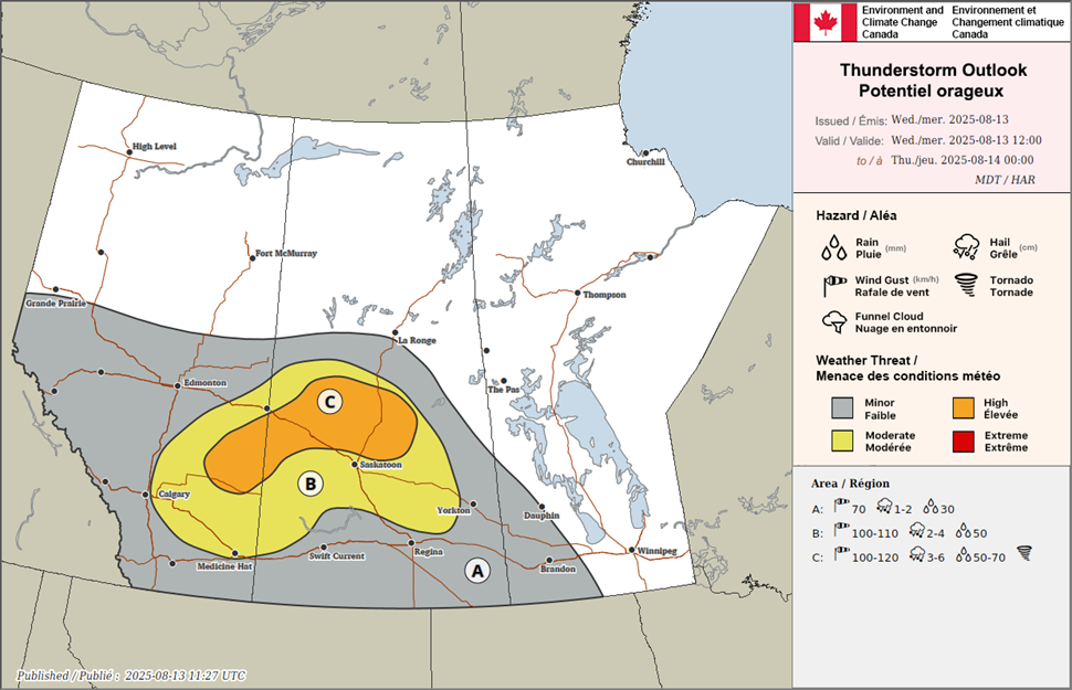
An active weather pattern is setting up across much of Alberta and Saskatchewan on Wednesday, with forecasters warning of severe thunderstorms, large hail and the potential for one or two tornadoes in parts of both provinces.
Environment Canada says a low-pressure system developing in the Alberta foothills on Wednesday morning will track east into west-central Saskatchewan by late afternoon. A warm front will stretch from the Battlefords region north of Saskatoon into southeastern Saskatchewan, while a cold front lingers across south-central Alberta.
The setup is expected to create a volatile environment, with forecasters pointing to moderate-to-high instability and strong wind shear. Backed surface winds along the warm front and veering winds will provide favourable conditions for rotating supercell thunderstorms.
Questions remain regarding capping in the warm sector and exactly where storms will initiate.

Initial storms could bring tornadoes, hail up to six centimetres in diameter and wind gusts over 90 km/h. As storms merge and grow in the evening, the main threats are expected to shift toward heavy rain and strong winds, with bowing storm structures possible overnight.
Overnight storms are forecast to continue into Thursday morning across the northeastern grainbelt and into central Manitoba, still carrying a severe threat and delivering 30 to 50 millimetres of rain in some areas.
While the storms could be damaging, meteorologists say the rain will bring welcome relief to wildfire-stricken and drought-affected regions of the Prairies.
Wednesday will be a day to monitor the skies closely in southern Alberta and Saskatchewan. The threat for supercells and tornadoes is on the table, alongside much-needed rainfall.
