Portage la Prairie has been heavily affected by wildfire smoke this summer, with haze and poor air quality contributing to the thoughts in many residents' minds, wondering if the season has already turned toward fall. But meteorologist Crawford Luke says the numbers show the region is still running close to, or even warmer than, normal.
Luke notes that three days last week reached 27 to 29 C with nighttime lows of 17 C, which was warmer than usual. While the weekend cooled off, he explains that “other than maybe a bit of cooler weather this past weekend, I don’t really have a lot of data that supports the notion of anything being cooler than normal.”
He adds that late August naturally marks the seasonal turn toward fall, but overall, the area has not seen anything particularly cold. “If we look at August as a whole, we’re actually on track to have temperatures that are near or even above normal by the time the month is over.”
Smoke plays the bigger role
Asked about the impact of heat from widespread wildfires, Luke explains that while intense fires can locally affect weather, the broader influence comes from the smoke itself.
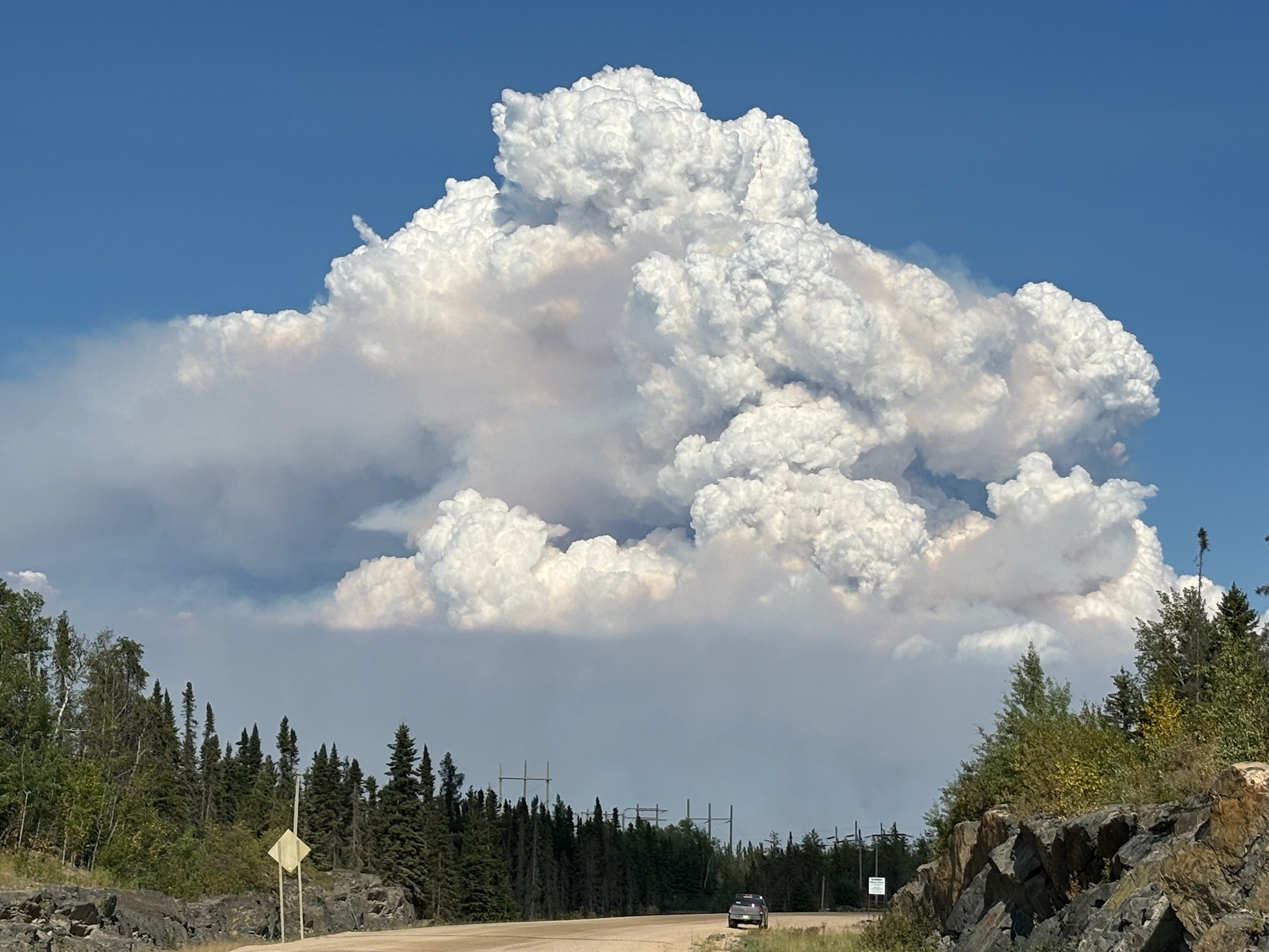
“We saw a case at Snow Lake a couple of weeks ago where a fire was just so intense it was actually creating its own weather a little bit,” he says. Such events can produce what is known as a pyrocumulus cloud, a thunderstorm-like system formed by extreme heat.
Luke continues, “We definitely see local effects like that. But otherwise, the more widespread effects tend to be the smoke that travels from those fires.”
He adds that thick smoke can even suppress temperatures. “If the smoke is thick enough, sometimes it can keep things cooler than they might have otherwise been. We saw that a few days this summer, especially back in July when the smoke was really bad.”
Fires across the country
Luke says that although fires generate immense heat, the lasting influence is still the smoke. “Obviously if you’re around the fire, you’re going to feel the heat from it. But on a larger, broader scale, it’s more of the smoke that we see having an influence on temperatures.”
He notes that widespread smoke this summer circled the northern hemisphere. “We were seeing smoke from the Prairies making it all the way to Europe,” Luke says. “Not necessarily impacting their air quality in the same way, but certainly giving them the hazy skies and red sunsets.”
Dangerous fire-created storms
Explaining further, Luke outlines how fires can generate dangerous weather. “The name is pyrocumulus. It’s basically a cumulus cloud created by fire,” he says. Normally, cumulus clouds form on hot, humid days, sometimes growing into thunderstorms. Fires, however, replace humidity with extreme heat to create instability in the air.
He adds, “In some cases it can lead to creating its own thunderstorm, and that can be bad news because you’re starting to create more lightning strikes, so that can sometimes initiate more fires.”
Such storms can also bring powerful winds, creating further risks for firefighters on the ground. Luke says these events are not uncommon during large, intense fires, citing recent examples in Snow Lake, Manitoba, and in British Columbia in past years.
Sign up to get the latest local news headlines delivered directly to your inbox every afternoon.
Send your news tips, story ideas, pictures, and videos to news@portageonline.com.
PortageOnline encourages you to get your news directly from your trusted source by bookmarking this page and downloading the PortageOnline app.