Prairie residents can expect warmer-than-normal conditions through October before a flip to a colder, stormier pattern in November, according to The Weather Network’s 2025 Fall Forecast.
The release said the transition from summer to early fall has already featured “a dramatic contrast in temperatures across Canada,” including “record breaking cold temperatures” in central Canada and “record shattering heat, especially in western Canada.”
However, it warned that “the relatively mild conditions are expected to come to an end during November with a return to a more active and changeable pattern, which is typical for late fall. This could include a rather abrupt transition into early winter for parts of Canada.”
“Fall is typically a turbulent and changeable season as we make the transition from summer to winter,” Doug Gillham, senior meteorologist with The Weather Network, said in the release. “However, during the heart of the fall season, from mid-September through October, we expect an extended stretch of more consistent mild weather with fewer than the typical number of fall storms for most of Canada.”
For the Prairie provinces, the network said warmer-than-normal temperatures will dominate through October, with only brief interruptions of colder weather, before a “much colder and more active pattern” develops in November.
Across Ontario and Quebec, the forecast called for a chilly start before warmer-than-normal weather sets in during the second half of September and October, with more sunshine and fewer storms than usual. In November, a more active pattern is expected with the potential for an abrupt transition into early winter. British Columbia is projected to start with warmer-than-normal conditions that quickly fade to near-seasonal, with the fall storm season arriving on schedule.
Warmer Pacific waters are expected to push rainfall totals above normal, raising concerns about excessive rain, though the ski season is still expected to start close to on schedule. Atlantic Canada is expected to be mild through October, with above-normal temperatures and fewer storms than usual, though the risk remains of being hit by remnants of a tropical system. Northern Canada will begin above normal, especially through the first half of the season, before shifting to a more active pattern with near or above normal precipitation totals and substantial snow and ice later in the fall.
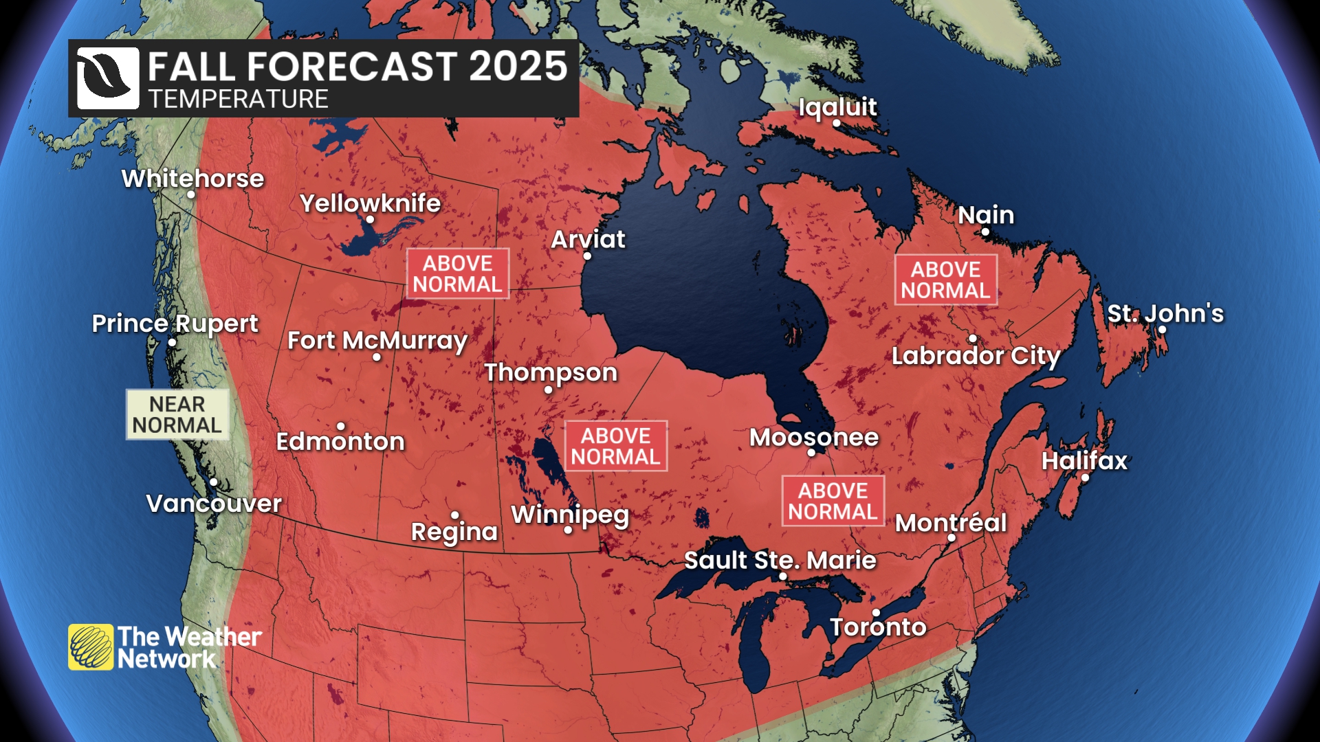
The Weather Network’s national outlook calls for above normal warmth across Alberta, Saskatchewan, Manitoba, Ontario, Quebec, Atlantic Canada and much of the North. Near normal precipitation is forecast for the Prairie provinces.
![]()
The forecast also said “warmer than normal temperatures will dominate through at least October across most of our country. This should provide periods of pleasant conditions for getting outside and enjoying Canada’s amazing fall foliage.”
Old Farmer’s Almanac calls Prairies warmer and wetter
The Old Farmer’s Almanac projected that “the Prairie provinces can expect a warmer and wetter-than-normal autumn.” September is expected to average 12 C, one degree above normal, with about 45 millimetres of precipitation, which is close to average. The month is forecast to begin with isolated showers and a cool dip, while mid to late September trends warmer with thunderstorms and a run of sunny, very warm days to close the month.
October is projected to average 8 °C, two degrees above normal, with 30 millimetres of precipitation, five millimetres above normal. Early October should bring warm, sunny conditions followed by light drizzle mid-month. Later in the month, western areas could see early flurries while eastern areas experience drizzle, before conditions warm again near the end of October.
In Atlantic Canada, the Almanac said September and October “will be cooler than normal, with above-average rainfall.” September will average 13 C, one degree below normal, with 160 millimetres of rain, 55 above normal. October is expected to average 7.5 C, one degree below normal, with 135 millimetres of rain, 15 above normal. It also warned of “a tropical storm … early in September,” followed by a mix of chilly sun, rain and mild spells.
Southern Quebec is forecast to be cooler than normal with mostly above-average rainfall. September is expected to average 13 C, one degree below normal, with 120 millimetres of precipitation, 30 above normal. October is projected to average 7 C, one degree below normal, with about 80 millimetres of precipitation, five below normal. September is expected to alternate sun and rain with generally cool conditions, while October brings scattered showers and chill, a warm spell mid-month, then cooler, showery days to close the season.
Southern Ontario is forecast to be cooler than average with above normal precipitation in the north and near normal in the south. September is projected to average 13 °C, two degrees below normal, with 120 millimetres of precipitation. October is expected to average 9 °C, one degree below normal, with 65 millimetres of precipitation, 10 below normal. September is forecast to start with thunderstorms and mild weather, then bring rainy, chilly periods with some sunny breaks. October should begin chilly with sun and light showers, warm mid-month with possible thunderstorms, then end with a mix of sunshine, rain and even a chance of early snow.
In southern British Columbia, the Almanac projected a warmer-than-normal fall with near-average rainfall. September is forecast to average 15 °C, one degree above normal, with about 100 millimetres of rain. October is expected to average 11 C, two degrees above normal, with about 100 millimetres again. Early October should be mostly sunny and warm, followed by isolated showers later, cooler spells mid-month, and rainy but warm conditions by the end.
Farmers’ Almanac warns of early snow in Prairies
“As autumn paints the Canadian landscape in vibrant hues, Fall 2025 is shaping up to be a season of dramatic weather contrasts across the country,” the Farmers’ Almanac said in its extended forecast.
It projected that “the fall season will trend cooler than average, particularly across the Prairie Provinces and Atlantic Canada.” For the Prairies, it said “early cold snaps and even wet snow” are possible by mid-October, with “more widespread snowfall expected across Ontario, the Prairies, and Atlantic Canada by November.”
The publication said Newfoundland and Labrador are expected to face frequent chilly spells, while southern Ontario and parts of British Columbia could see “some of the warmest and most temperate days of the season, especially in early October and mid-November.”
It also said “rain will be a recurring theme for Canada.” Atlantic Canada is forecast to see a wet September “with a threat of a hurricane mid-month.” Ontario and Quebec are expected to contend with heavy showers and thunderstorms throughout October, while British Columbia is projected to experience frequent Pacific-driven rain systems. Higher elevations in Quebec, British Columbia and the Prairies may see wet snow as early as October.
The Farmers’ Almanac said Thanksgiving weekend, which falls on Oct. 13, will offer “a brief reprieve from the unsettled weather” in Ontario, Quebec and B.C. with “pleasant, partly sunny conditions.” The Prairies, however, may see rain or wet snow, and Atlantic Canada is expected to remain cool. For Halloween on Oct. 31, it projected that “Ontario and the Prairies may see a mix of rain and snow, while British Columbia could face stormy conditions. Provinces on the Atlantic Coast will likely be cool and showery.”