Airdrie city council has approved a Community Area Structure Plan for the city’s east side that could add nearly 6,000 homes and more than 16,000 residents over the next three decades.
![]()
The East Nose Creek Community Area Structure Plan cleared all three readings on Sept. 2, passing unanimously with Mayor Peter Brown and Coun. Darrell Belyk absent.
“We’re in the city, but we’re not in the city,” a Fairways Drive resident told council during the public hearing. She said her community had been “leapfrogged” without water, sewer or garbage pickup for 12 years.
“Failure to plan is planning to fail,” she added.
![]()
Council also carried a resolution to direct administration to schedule and facilitate a meeting with residents who spoke at the public hearing and those in the special study area, along with some council members, to discuss their concerns.
Plan and scope
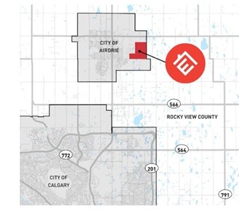
The East Nose Creek Community Area Structure Plan area covers about 450 hectares — 1,112 acres — bounded by Range Road 291 to the west, Yankee Valley Boulevard to the south, Yankee Valley Estates to the west, and the Rocky View County boundary to the east. A Nose Creek tributary bisects the site, identified as “East Site C” under the O2 ecological inventory.
![]()
B&A Planning Group submitted the application on behalf of a land ownership group led by Spring Valley Estates Corp. (Highfield Land Management), joined by Reliance Land Group Ltd., represented by Lansdowne Equity Ventures, and five additional landowners.
Senior planner Daria McDonald told council:
“The CASP covers 450 hectares, or seven quarter sections at full build out. The area is anticipated to accommodate approximately 14 to 16,000 residents and approximately 3,000 jobs over the next 20 to 30 years.”
![]()
According to the CASP, the area is projected to contain 5,103 to 5,740 dwelling units, 14,338 to 16,131 residents, and 3,427 jobs.
The land is divided into five neighbourhoods, labelled A through E, to be developed sequentially based on servicing and transportation capacity. Full build-out is expected over more than 20 years.
Land use and policy
According to the CASP, five school sites are to be dedicated as part of municipal reserve, with a maximum of six elementary, middle or junior schools to be confirmed at the Neighbourhood Structure Plan stage. The CASP also provides one high school site of about 8.0 hectares (20 acres).
Policy 3.3.8 states the five neighbourhood nodes “should collectively include 10 acres of commercial use, which may include vertical mixed use. The details of each node would be determined at the neighborhood Structure Plan stage, and should the developer wish to reduce the commercial amount they may request at that time that the city undertake a market assessment at the developers cost.”
![]()
According to the CASP, two larger commercial areas are placed near Range Road 292.
The Planning Analysis indicates that, compared to the 2023 justification report, commercial land has been reduced by 16 to 26 acres.
The Planning Analysis also notes industrial land increases by about 78 acres, an adjustment it says aligns with the council’s 75:25 residential to non-residential tax assessment target.
The CASP prohibits new residential development inside the Noise Exposure Forecast 30+ contour tied to the Airdrie AirPark. Neighbourhood D holds the largest share of non-residential land use due to this restriction.
According to the CASP, technical studies include a Biophysical Inventory Report, a Phase I Environmental Site Assessment, the O2 Ecological Inventory, and a 1964 reclamation certificate for an abandoned petroleum hydrocarbon well in SW 6-27-28-4.
Environmental and heritage
According to the CASP’s biophysical inventory, the plan area contains 17 wetlands, three streams, six ephemeral drainages and one provincially significant Environmentally Significant Area, recorded with a value of 0.288.
According to the report, wildlife observations were incidental, and glacial erratics were also noted on the site.
The Phase I Environmental Site Assessment, cited in the CASP, identified a reclaimed petroleum well in SW 6-27-28-4 requiring a minimum five-metre setback.
The CASP records that the ESA also noted odour complaints of sulphur dioxide and hydrogen sulphide emitting from the area and uncertainty about the well’s depth.
The ESA recommended supplementary Phase I investigations for three residential properties and one commercial property, decommissioning of any septic tanks and disposal fields, and hazardous building materials surveys before demolition or renovation.
According to the CASP, an ATCO pipeline corridor crosses the site.
The plan also states a Historic Resources Impact Assessment will be required at the Neighbourhood Structure Plan stage for archaeological and palaeontological resources under the Historic Resources Act.
Transportation and servicing
According to the CASP, planned transportation upgrades include widening Yankee Valley Boulevard, expanding Range Road 291 and creating a new Range Road 292 north–south connection that will eventually extend to Veterans Boulevard.
The Planning Analysis says Yankee Valley Boulevard and Veterans Boulevard are to be widened to four lanes at the 200,000 population horizon and to six lanes at 265,000. Range Road 291 is to be widened to four lanes at a cost of $265,000.
According to the CASP, multiple roundabouts are identified at collector intersections.
The plan states that the arterial and collector road network shall accommodate future transit routes and stops, with local routes and stop locations to be finalized at the Neighbourhood Structure Plan stage.
According to the CASP, water servicing depends on additional Calgary capacity, including the Southeast Reservoir and new supply mains.
The plan sets out a phased water servicing strategy for the area.
According to the Planning Analysis, sanitary service will rely on Lift Stations 6 and 7 and the Southeast Wastewater Trunk Sewer, with regional upgrades to Calgary anticipated to be complete in 2028.
The CASP states stormwater will be managed through four facilities discharging south to Nose Creek, integrated with wetlands. The exact routing and conveyance will be determined at the Neighbourhood Structure Plan stage.
The Planning Analysis says the area will be primarily served by the Highland Park fire station, with a seven-minute response time.
Funding framework
According to the CASP, each benefitting party must pay a proportionate share of regional infrastructure costs.
The plan says developers are responsible for constructing local and collector roads, as well as water, wastewater and stormwater infrastructure, which must then be dedicated to the city as contributed assets.
The CASP notes that off-site levies will fund arterial roads, major water and wastewater systems, and regional stormwater facilities.
It also states city contributions are subject to the annual capital budgeting process.
According to the CASP, Section 7.2 adds that cost-sharing and timing are flexible and remain subject to council approval.
The public hearing report noted Section 7.2 was amended after CISG review to provide greater flexibility in determining funding mechanisms and to align with council’s capital budget priorities.
Administration’s presentation
McDonald told council the plan includes housing, employment areas, schools, including a high school, neighbourhood nodes and open space, and is consistent with the Twelve Thousand Acres Plan and council’s May 2023 justification approval.
She said the plan establishes five neighbourhoods. Neighbourhoods B and C are larger to account for the creek, and Neighbourhood D is primarily non-residential because of Noise Exposure Forecast contours tied to the Airdrie AirPark.
She explained that Policy 3.3.8 requires the five neighbourhood nodes to collectively include 10 acres of local commercial use.
“This may include vertical mixed use. The details of each node would be determined at the neighbourhood Structure Plan stage, and should the developer wish to reduce the commercial amount, they may request at that time that the city undertake a market assessment at the developer's cost.”
The open space system, she added, is anchored by the Nose Creek green corridor, consistent with the O2 ecological inventory.
She emphasized that schools are conceptually located adjacent to collector roads, with final locations confirmed at the Neighbourhood Structure Plan stage.
She said transit is to be integrated at the NSP stage, with routes on arterials and collectors and active transportation pathways along collectors. Off-street pathways, she noted, will be considered at the NSP stage as municipal reserve permits.
McDonald concluded that administration supports the plan because council approved the 2023 justification, the lands are contiguous, and the CASP provides schools, nodes and housing while aligning with the City Plan, AirdrieONE and other guiding policies.
Councillor questions
Coun. Candice Kolson pressed administration on schools and commercial nodes.
McDonald replied: “We have left them conceptually located at this stage deliberately, because they do tend to shift the locations at the NSP stage. So we've kept the conditions that they have to be located adjacent to collectors.”
Kolson asked if mixed use could default to residential.
McDonald said, “There is vertical mixed use and horizontal mixed use. So, yeah, at the time of the NSP, we would have those discussions with the applicant.”
Kolson also asked who approves NSPs.
Jordan Furness, policy planning, answered: “Yes, I can confirm that neighbourhood structure plans … have, historically and continue, will continue to come to Council for approval.”
Coun. Tina Petrow pressed administration on the site’s ecological value.
Clint Goodman, environment specialist, replied: “Above average generally pertains to have areas having maybe highlights of native grassland or wetland features …”
He added that it could also reflect “topographical slopes that may indicate a more significant or higher chance of sensitive areas in the context of Airdrie local.”
Petrow noted a 221-page biophysical inventory filed separately and asked what it contained.
Goodman said: “The CASP document captures the summary of that already … wetlands and wildlife features and glacial erratics and all those elements that may present themselves.”
Petrow also asked about changes in funding language between the version seen by the Community Infrastructure and Strategic Growth Committee and the one before council.
McDonald replied: “Yes. So there was a more detailed description of that in the previous version that went to CISG, and it was brought up to a higher level to allow for more flexibility at the subdivision stage …”
Coun. Al Jones raised the issue of creek crossings.
Administration replied: “For example, with respect to this tributary, it's a ground claim water body. So, the Public Lands Act would have some oversight … as well as the Water Act would apply …” [sic]
Coun. Heather Spearman pressed the administration on whether reduced commercial land was offset by more industrial space.
Chad Sheldon, economic development officer, answered: “The overall non-residential component actually increases … we were happy with the slight trade off, which meant a higher non-residential assessment.”
Spearman asked if his department supported the plan.
Sheldon replied: “Yes, we were engaged the entire time and are very happy with the result.”
Coun. Ron Chapman asked about glacial erratics on the site.
McDonald said: “There’s a historical resource impact assessment required at the NSP stage … the province would be informing us whether there’s any erratics of significance that are required to be protected under provincial legislation.”
Chapman also asked about servicing.
Andrew Dormer, engineering, said: “We wouldn't envision a lot of development … until after we have some of the regional infrastructure built, obviously, the new waste water line to Calgary, and probably a new supply main from Calgary as well.”
Applicant’s presentation
Lauren Lambert, Senior Planner with B&A Planning, told council:
“We believe this plan represents an important and exciting step forward in Airdrie's continued growth, one that builds on the city's long-term vision.”
She added:
“Within the broader framework of East Airdrie's planned lands, the East Nose Creek CASP establishes a cohesive and well-integrated community vision.”
Resident presentations
During the public presentation, however, several residents voiced concerns and frustration. One Fairways Drive resident said her family had “no water, no sewer, no garbage pickup,” and had been “leapfrogged” for 12 years.
Another Fairways Drive resident said he owns 17 acres, with about 520 acres total in the special study pocket. “It’s time … it’s on the city, it’s on planning. You have a team — let’s plan.”
Another Yankee Valley Estates resident said six acres border the CASP and asked that multi-family housing not be placed directly behind their properties, citing “height and noise … privacy, all of the above.”
While another Yankee Valley Estates resident said he wanted to “figure out a way how to engage in this process … to ensure that what comes of the neighbourhood structure plan and indeed is what happens.”
He told the council his son’s neighbourhood “started as one thing, ended as another with quite a bit of density that wasn’t expected.”
He also suggested: “Maybe the answer is two acres.”
Council wrap-up and vote
Deputy Mayor Ron Chapman said: “This city is growing crazy. If somebody would have told me 20 or 30 years ago that we'd be here discussing residential out that far east. I would have never guessed that, but not Not in a million years.”
Coun. Tina Petrow said: “I think a lot of that ecological stuff is where I'd really like to see how that plays out …”
Coun. Candice Kolson said: “I just want to say that most of my concerns will be need to be addressed at the NSP process, that when it comes to the CASP, I'm okay with it going forward NSP, I might be a little bit more picky at that time, so I just, I will support it moving forward."
Community planning process in Airdrie
According to the City of Airdrie’s website, new communities go through several stages before construction can begin.
The process starts with a Community Area Structure Plan justification report, which must be approved by council. The report provides the rationale for long-range planning under the city’s 12 Thousand Acres Plan.
Once that approval is in place, council can adopt a Community Area Structure Plan. A CASP sets the broad framework for land use, roads, servicing and infrastructure, and is required before rural or greenfield lands can be redesignated for urban development.
Developers must then prepare Neighbourhood Structure Plans for each quarter section. An NSP identifies local street networks, exact locations for schools, parks and pathways, the housing mix and servicing details. NSPs require council approval through a public hearing.
After an NSP is approved, council considers zoning, which divides property into districts that regulate what types of buildings and uses are allowed. Subdivision follows, dividing land into smaller parcels that can be sold or developed. Most subdivisions are approved administratively.
The final step, the city notes, is development and building permits, which must be issued before construction can begin.
Sign up to get the latest local news headlines delivered directly to your inbox every afternoon.
Send your news tips, story ideas, pictures, and videos to news@discoverairdrie.com. You can also message and follow us on Twitter: @AIR1061FM.
DiscoverAirdrie encourages you to get your news directly from your trusted source by bookmarking this page and downloading the DiscoverAirdrie app.