
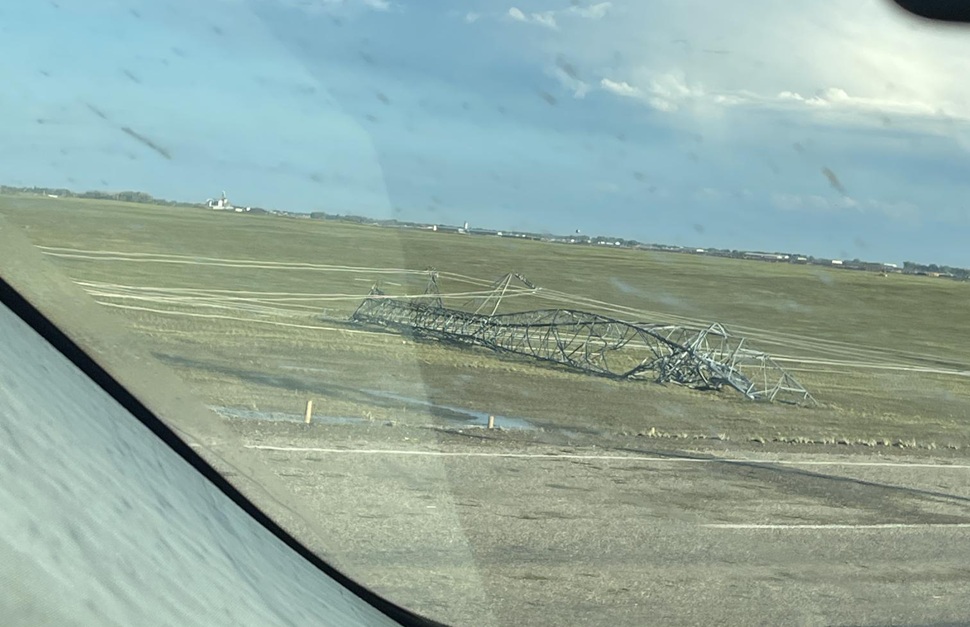
Storm-related debris littered the region Thursday morning as West Central residents woke up to the aftermath of a fierce overnight system that brought heavy rain, hail, and powerful winds that certainly left their mark across the area.
After a hot day on Wednesday with relatively nice weather, the script flipped from clear blue skies to dark clouds and increasing winds into the early evening. Models showed two separate systems on a collision course Wednesday evening, each creating their own wild conditions before merging around Saskatoon.
"We had this supercell system that formed just west of the Battlefords, kind of late in the afternoon around 4:00, 4:30 or so," said Environment Canada meteorologist Crawford Luke. "Really got going around 5,6 o'clock."
Golf ball sized hail entered the picture as the Battleford area storm really started kicking off around 5:30, but triple-digit gusting winds were the main story according to Luke.
"We actually had wind gusts of 129 km/h from North Battleford. Had another station in the area that gusted over 110 km/h, so very strong winds."
Luke confirmed that system later merged with another one east of town and eventually travelled southeast along Highway 16, where Saskatoon area residents were eventually treated to the nasty conditions, and hail that dwarfed the golf-ball sizes reported earlier.
"As they went over Radisson... actually produced tennis ball sized hail," said Luke, who confirmed some windshield casualties as the 6.5 cm in diameter bombs fell from the sky.
The nature of the storm kept the damaging conditions north of Saskatoon. It continued eastward to around Humboldt, and that's when the tornado threat started to emerge according to Luke.
"This would have been between Middle Lake and Cudworth, just northeast of Saskatoon. We got a report of a tornado there from a storm chaser in the area, so we are looking into that today," said Luke, also adding that there were 13 tornado warnings issued across the province Wednesday.
Related Stories:
- UPDATE: Severe wind and storm shreds infrastructure near Leader
- Elrose area slowly getting back to full power after Wednesday night outage
While that was the storm of the day for many, the other system of note came from near the Alberta border and caused similar problems to the south.
"We had these other storms kind of firing off up and down the border with Alberta. Particularly, south of Kindersley there was another pretty strong supercell... Kindersley itself did actually gust up to 116 km/h from these thunderstorms," said Luke, as ping-pong ball sized hail was also part of the system but stayed south closer to Sceptre and Mendham where there were also reports of flooding.
The fast-moving nature of each storm was another commonality according to Luke. The storm ripping through the Battlefords was about 40-50 km/h, while the Kindersley area storm was clipping along at over 100 km/h.
"That's pretty fast for a storm. And when we see storms move that fast it is a bit easier for them to generate wind gusts, so it makes sense we saw 116 km/h at Kindersley based on how fast it was moving."
Thankfully, Thursday is offering a nice day for anyone cleaning up in the aftermath of the storm.
Temperatures have dropped significantly from the near +30 values seen earlier in the week but are still coming in nice around the mid-20's alongside a noticeable northwest breeze.
Expect those conditions to stick around through the weekend with some cloud cover making an appearance, but looking ahead, starting Sunday it's expected to be nothing but sunshine with highs creeping up from 24 on Sunday to a possible high above 30 on Wednesday.